
When was the last time you sailed down the Detroit River to Bob-Lo Island, to summertime?
Before July 30, 2011, my last visit to Bob-Lo had been in June of 1968. On that trip, my companions on the Bob-Lo Excursion Line steamer were other ninth graders from Livonia’s Holmes Junior High. We were participating in a totally sanctioned, transportation-provided-by-the-school-district “Ninth-Grade Skip Day.” We would have boarded either the Ste. Claire or the Columbia, but no cellphone cameras documented that embarkation and carrying a Kodak Instamatic simply would not have been cool. On that visit, the very air between the Wild Mouse and the Whip was fraught with hormones dancing to a Top Ten soundtrack which included “Sitting on the Dock of the Bay” and “Grazing in the Grass.”
Over four decades, later, on July 30, 2011, I spent an afternoon on Bob-Lo . . .

Flags at the Amherstburg Dock
To get to Bob-Lo Island in the 21st century, you take a ferry from Amherstburg, Ontario, instead of from the old dock on Jefferson Avenue in Detroit. The ferry leaves every 20 minutes from a dock next to the “Bob-Lo Discovery Centre.” The ride takes about 5 or 10 minutes, instead of the hour it used to take when one departed on the other side of the border.
From the U.S. (departing from Detroit) your route to the ferry would look like this:

To Amherstburg ON from Detroit
The ferry boat captain had to take the Detroit River’s strong current into consideration in maneuvering the ferry boat to the dock.
Crossing the Detroit River to Bob-Lo from Amherstburg, ONOfficially, Bob-Lo Island is now billed as a “Marina Resort Community,“ but Bob-Lo currently exhibits the most profound split personality of any island–perhaps any place–I’ve ever been. Which may not be surprising, given that it’s been many things—camp for European explorers, fortress, picnic spot, dance venue, amusement park, retreat—to many people over the centuries beginning with four Algonquin and Iroquoian tribes: the Ojibwa (Chippewa), Ottawa, Potawatomi and the Wyandot (Huron)–one source claims the original name of the island was Etiowiteedannenti, a name bestowed by the Wyandot–and followed by:
- The French
- The Jesuits
- The British
- Canadians
- Slaves (traveling the Underground Railroad)
- American tourists
- Investors.
The first recorded passage to the island, which was named Bois Blanc (“White Woods”), by the French dates from 1670. I learned this and most of what I know about the history of Bob-Lo Island from 1670 – 2006 in the book Summer Dreams: The Story of Bob-Lo Island by Patrick Livingston (published in 2008 by the Wayne State University Press in Detroit as a part of their Great Lakes Books series):

“Summer Dreams” by Patrick Livingston (Wayne State University Press, 2008)
How does Bob-Lo Island appear today, Saturday, July 30, 2011? When you disembark from the ferry, you find yourself adjacent to a private very well-to-do residential area. To the north of the road leading from the ferry dock is a subdivision of mini-mansions and duplexes, with an emphasis on stone and heavy on Victorian-style turrets. The subdivision consists of a loop of a street containing a court within the loop. On the south side of the road leading from the ferry dock is a five-story condominium:

Condo Building on Bob-Lo Island
Between the river and the condominium is a trail which heads south along the island’s perimeter and allows a walker or bicyclist to view a number of historical structures, including the Sailor’s Monument, which still graces the eastern shore of the island:

Sailor’s Monument on Bob-Lo Island
The commemorative plaque affixed to the Sailor’s Monument reads:
“Dedicated to 134 years of American-Canadian friendship across 4500 miles of unfortified border, protected only by the mutual respect and understanding one nation holds for the other.
Presented in the name of the border cities of Detroit, Windsor, and Amherstburg.
Commemorating the 50th anniversary of the Bob-Lo Excursion Company and the 50 years of Canadian-American use of Bob-Lo Island as an International recreation area
June 18, 1898 – June 18, 1948″
By golf cart or bike or on foot are the only ways to navigate the crushed limestone trails that cover the remainder of the island, but for the residential area (the only place where cars are allowed). The folks from the residential areas use golf carts to get to the community pool in the center of the island, just a stone’s throw from the almost hundred-year-old, still standing Dance Pavilion:

The Bob-Lo Island Dance Pavilion
And here is where things get interesting. Scattered over the rest of the island, there are still a number of structures left from other eras—midst overgrown grass, downed limbs from trees, and more than a few other surprises:
At the south end of the island, two pieces of history, although damaged, still stand:
- The south blockhouse, built in 1838 (Update: See http://www.huffingtonpost.com/2011/11/17/historic-boblo-island-blo_n_1098807.html); at one time, there were a total of four blockhouses built by the British on the island:

- Southern Blockhouse on Bob-Lo Island
- The Bois Blanc Lighthouse built in 1836; its lamp room was destroyed in 1954 when vandals started a fire.

Bois Blanc Lighthouse
In the portion of the island that was once the amusement park–“Bob-Lo” as the babyboomers knew it–a number of structures still stand:
- The Carousel Building, built in 1905 to house the first amusement ride on Bob-Lo Island, served as a convention hall and later, the roller-skating rink (beginning with the 1940 season) before ending up as a theater. Today it is overgrown:

Built to house the carousel, Bob-lo’s foray into the amusement park business began with this building in 1905.
- The Powerhouse, which looks like small limestone chapel, that provided electricity to the Carousel:

Powerhouse was built to supply electricity to the Carousel and remainded the only source of power on the island until into the 1950s.
- The Dance Pavilion – a 35,000 feet steel and limestone building designed by Albert Kahn and John Scott and completed in 1913.

Bob-Lo Island Dance Pavilion
Unfortunately, despite a private-property-no-trespassing sign . . .

If only . . .
. . . the building is not secure, given that one-quarter of a large window in the front is broken in, metal strips hanging from its frame. Peering through the broken glass, one can see water covering portions of the floor.

Is this any way to preserve a building, the centennial of which will be celebrated in 2012?
Wild grapevine has made it to the second floor balcony of the gallery.

Ghosts among the grapevines
One can’t imagine a happy centennial celebration for this historic building . . .
- Or for the Lavatory building next to it, built to match the other stone buildings on the island.

Lavatory Building adjacent to the Bob-Lo Dance Pavilion
Poison ivy now grows in the ring of mature trees in front of the Lavatory building, where I imagine the men in hats retiring for a smoke while they await their dates in flapper attire to emerge from “The Ladies Room.”

Bob-Lo Lavatory Building Door
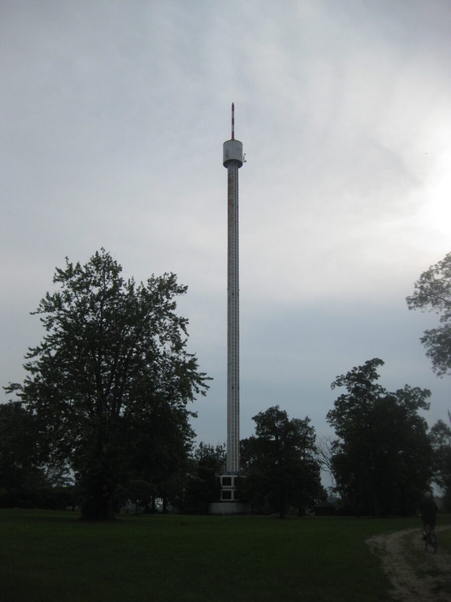
- The 375-foot Sky Tower, rusting and visible from the Powerhouse and most of the island, as well as from other locations on the river like Grosse Ile:

Bob-Lo Island Sky Tower still marks the spot on the Detroit River.

Did you ever wait in line here to go to the top of the Sky
Tower for the view?

The top of the Sky Tower
- And a few other buildings, like the open one that may have housed the dodg’em cars built in 1928, and another with more shattered windows, the Souvenir building:

Bob-Lo Souvenir Building
- The terminal building:

Terminal Building
Obscured in a small wooded area between the Dance Pavilion and the Terminal are the remains of the minature golf course:

Tee time, anyone?
Consider this: I did not see another person during my entire afternoon exploration of the historic sites on the island, except for three young teenage girls I observed leaving the Resort’s community pool and making their way down to the river alone, to the channel between Bob-Lo and Amherstburg, where, nestled next to the Terminal, is a very small sand beach where they swam. Between my concerns for the submerged rocks of the river and the mortar of history I was climbing over, I thought, what a wonderful place this island would be to explore if you were a kid or teenager and what a nightmare it poses for parents or grandparents of those explorers! I can only imagine the dangers of the dilapidated buildings, to say nothing of concerns about strangers. Although I had $8.00 in Canadian currency in hand to pay the ferry toll, I rode the ferry without being charged and with no questions asked. Of more concern than strangers arriving by ferry would be the boats that pull up and anchor around the island on summer days.
Particularly down at White Sands beach below the Lighthouse (http://www.flickr.com/photos/33535417@N05/4112593095/), where two boats were anchored during my visit to the south end of the island with a large group of partying young people. Livingstone writes that the white sand beach was created in 1957 when a vein of sand in the mouth of the river was dredged by the U.S. Army Corps of Engineers as they deepend “the Amherstburg Channel to St. Lawrence Seaway standards, opening the Great Lakes to the world.”
Boater can also dock at the “Boblo Wharf” on the west side of the island, to eat at the Bob-Lo Island Beach House Restaurant.

Bob-Lo Marina behind Beach House Restaurant grounds

Bob-Lo Island Beach House Restaurant
Visiters to the marina can visit the small gallery of photographs and paintings of water scenes or rent bikes to explore the island (although what appeared to be the bike rental building was closed on this July Saturday, so perhaps not).

The bike rental shop was closed, but you can check your weight for free.
The biggest surprise during my visit to Bob-Lo came from a different sort of stranger than the type I’d been envisioning when I was watching the girls swim in the river. When I was riding my bike on a trail that runs through the middle of the island, I came upon a T-intersection buried amidst tall, tall grass, with the Carousel Building on my left and the Powerhouse on my right. Suddenly, without any warning, there was a relatively large mammal in the middle of the trail, directly in the line of my front bike tire. Having trotted out into the intersection, clearly not expecting anyone to be on the trail, the animal froze and then turned and shot back up the path, between the tall vegetation on each side, its hind legs trying to gain purchase on the crushed limestone. The juvenile coyote was gone in another blink of the eye.

My Bob-Lo friend is safe.
The Bobl-Lo Island of today? A retreat for the wealthy, amidst dilapidated remnants of history and ghosts of the past, with nature ever encroaching.
The first thing I did when I got back home was to search for a Bob-Lo Historical Society on the Internet. Unfortunately, my search came up empty. There appears to be no such organization, which may not be so surprising. The existence of such an organization would certainly be complicated by the facts that 1) Bob-Lo is a Canadian island with an overbearing American past, and 2) today Bob-Lo primarily serves as a retreat for the wealthy, who I can imagine would not want people coming to visit the historical remains there, any more than they would want hunters (although if they own a cat or a small dog, the latter might be welcome if they could take care of the coyote population).
Other islands I’ve visited have their own historical societies or have joined with other nearby islands to form a historical society: Johnson Island Preservation Society, Lake Erie Islands Historical Society, St. Clair Flats Historical Society, Beaver Island Historical Society, the Grosse Ile Historical Society, and Friends of Bell Isle (now a part of the new Belle Isle Conservancy). Each historical society serves as a bead on a rosary linking current and future generations to the past, acts as a tool to support prayers of keeping the memories alive, keeps a link to the human roots of a distinctive place that has meant many things to many people over the years.

The Detroit River from the west shore of Bob-Lo Island
In this respect, today, Bob-Lo Island appears a bead broken off from the strand, adrift in more than just the Detroi River, its historic integrity drowned in the current of a sequence of ill-fated development schemes.


What a shame, all gone because some mega millionaires wanted more money. We don’t save anything for history any more. Places like fort custer, MI and fort sheridan, illinois, all sold to profiteers. Really sad
Well I would say as a resident (who by the way is not a mega millionaire), that we don’t mind having company on the island and share it with those who want to come out. It is a wonderful place with beautiful heritage and history, that is why I chose to live here. Please don’t judge us without knowing us! I don’t think it is sad at all!
Michelle, I interpret Roy’s use of the phrase “mega-millionaires” as being in service of describing the island developers, not the residents. My concern with respect to Bob-Lo Island is that what structures are left from the island’s very interesting history are not being adequately protected.
I’m glad you made this comment. People should not be making assumptions about the island residents. I grew up visiting the island and I’m hoping to return to explore it again someday.
I had the pleasure of delivering a load of stuffed animals to the Park in the early 1990’s, was a trip i will never forget, driving my Freightliner truck and a 48 foot trailer onto the wharf to make the trip across the river in the middle of the night over to the island then driving around the the park, having to stop and wait for the park benches to be moved for me to able to get truck and trailer around the turns stopping here and there to off load these stuffed toys into little electric carts for the arcade games before the park opened the next day, Friday of a May 24 weekend.
I agree with Maureen. The place is oozing history. It’s a wonderful feeling strolling the island, standing next to buildings where 10’s of thousands of souls now long departed use to frequent. Just read one of the many postcards you can find online from people back in the day. I believe the unfortunate combination of being a Canadian island with almost all American history is the reason it’s not being cherished by people in Canada. Not one thing mentioned on the dance hall being 100 years old this year.
when was the last day of this park operated (i mean the last summur )when it was open for public for the last and until what day was the ferry or the steamer making trip, and can you visit it now
The last summer that Bob-Lo operated as an amusement park was almost two decades ago: 1993. The steamers, the Ste. Claire and the Columbia, as well as their Detroit docks, had been divested a few years earlier in 1991. You can visit the island now, as I did in July of 2011 (all the photos accompanying the blog posting above were taken on that visit), by taking a small car ferry across a narrow strip of the Detroit River from the “Bob-Lo Discovery Centre” in Amherstburg, Ontario. It’s maybe a five-minute ride, no more than 10 minutes with the docking. As one can use motor vehicles only in the northern residential tip of the island, if you plan to explore the island, you may want to bring a bike with you. Although there was a bike rental business near the marina and Beach House Restaurant on the west side of the island (the ferry dock is on the east side of the island), it was not open for business on the beautiful summer weekend day I was there, so I wouldn’t count on being able to rent a bike on the island.
It was just announced in The Windsor Star that the dance pavilion is now for sale. Potentially, it could become a wedding reception hall or hotel.
With probably more than a bit of clean-up and reconstruction, it would make a wonderful venue for a wedding reception!!!
I agree. The beautiful wood flooring should never have been ripped out. It was a terrible idea to put a roller coaster in there. It’s too bad they couldn’t have it ready for this year to celebrate it’s 100th anniversary.
I agree with both of your comments, RC.
I was just in Amherstburg Sunday May 27,2013. And I stood and looked across the river, and what I remember is no longer there, and I’m 54 years old . It broke my heart to see the way everything looks these days. With all the history on that island, I don’t get it why it was left to die. My twin daughters, now 35, remember, but my son, 28, will never know. Neither will my grandchildren.
Can you go over to the island any time? I just would like to see what’s there and for my family to share it with me.
Thank you,
Kathi
Boblo Island is accessible by a 16-car ferry that departs from the dock next to the Bob-Lo Island Discovery Centre, which is at 340 Dalhousie St., Amherstburg, ON. The ferry runs 365 days a year, departing every 20 minutes. The ferry is run for the island residents, their guests, and prospective buyers of lots in the Triamico Development Affiliates’ “marina resort community.” However, there is a public restaurant, the Bob-Lo Island Beach House, on the west side of the island by the marina (ferry docks at the east side). The restaurant just opened for the season on the 24th, this past Friday. Ferry passengers could be going to the island to patronize the restaurant. Or not. Bring a bike or plan to hike as the only streets to accommodate cars are in the development.
Is it an easy walk to the restaurant on the west side from the ferry dock?
Yes, Kathy, the Bob-Lo Island Beach House Restaurant is an easy walk. Only about a third of a mile–a 5 to 10-minute walk, depending on your speed–from the ferry dock on the west side of the island, east on Bob-Lo Island Boulevard, to the marina on the other side of the narrow island. The restaurant’s 2013 “grand opening” was May 24th. It may be under different management than when I had a pretty tasty perch sandwich there, but you can find out more, including their hours at: http://www.boblo.ca/pages/living/restaurant.html
Thank you very much for info. My birthday is coming up, maybe my family can take me to the island. Thank you again!!
Kathi
As a child I went to Bob-Lo Island every summer from the Detroit Side of the island. I loved going there as it was much smaller than Cedar Point so riding the rides didn’t take so long. I did notice, however, the last time we went the island had gone downhill quite a bit. Quite disappointing that we never went back, management was doing a terrible job. I’ve always wondered about the island and have wanted to go back. Its sad that my kids will never be able to go there and ride the same rides I did as a kid.
I agree, Jennifer, very sad. I, too, went there every year as a child from Detroit. The island has quite an interesting history. If you’re interested, check out Patrick Livingston’s book “Summer Dreams: The Story of Bob-Lo Island,” published by Wayne State University Press in 2008. As well as some great stories, it includes some good photographs from all of the island’s incarnations!
I just kayaked to Boblo Island today, and I saw so much potential left in this land. I wish that the people that bought this island could restore it. I know the kids and people of this generation are definitely looking forward to more developments. It’s very sad because growing up that was all everyone talked about was Boblo Island, and all the amazing memories. I’d built up this image of perfectly cut green grass, flowers, water slides and party halls, but what I saw when I stepped onto the old white dock was far from the oasis I was told about. By each step it became more clear that this was left for dead a long time ago. One step on the old dock, and I saw an old run-down white platform, no life, no care in world…like everyone was evacuated and told not to come back. If I had “mega-millions” I would invest in restoration of the island and the amusement park. I would bring back the lost souls and add life to the island again. For the people who bought property there–you bought land that was so important to the neighboring cities and had brought so many families together. You support the “mega millionaires” who don’t care about anything else in life except their bank accounts. It is not fair that these people can just take away the little bit of history we have left just so they can watch their bank accounts rise. I do hope that someone will come along and restore the park back to its prime, so we can get families and the community back together again, and we can share our memories with the generations to come.
I agree; it would be wonderful if the park could be restored or perhaps, reinvented to serve in a new way of bringing community together!
To rebuild would be one of life’s pleasures. I would make sure my friends knew all the history of Bob-Lo.
People quit coming in the 1980’s, then the money for upkeep is not there. Not fair to blame millionaires when often it is a corporation that can run out money after 5 or 6 bad years. Hundreds of small amusement parks went out in 1980’s as families all went to super amusement parks like Cedar Point and Six Flags and did not visit small ones often.
We live on the east shore of Grosse Ile, we would love to take our boat to eat at the restaurant. I enjoyed BobLo so much as a child-we boarded the boats in Wyandotte. My husband is from
St. Clair Shores (1950′-60″s) & never went to the park. Is there a safe dock area, in which to leave our boat-(also Draft/depth) info .Is there a dock fee? Boblo Island was very special. We need to preserve what we have left, just for history’s sake. Look at Sugar Island…….it once was a special place.
There is a dock at the restaurant on the island, Sue. I don’t know about draft/depth info or dock fees, not being a boater, myself, and having instead taken the ferry from Amherstburg, Ontario. You can find the Boblo Island Beach House restaurant on Facebook: https://www.facebook.com/BobloIslandMarina Also the Boblo Island Marina: https://www.facebook.com/BobloIslandMarina You may be able to get the information you need by writing to: BOBLOMARINA@BOBLO.CA You may want to mention you’re coming from the States; I don’t know the protocol for private boats crossing the international border in the river to dock. This year, I hear there’s an ice cream concession, Captain Bob’s on the island (http://www.rivertowntimes.com/?s=Captain+bobs&submit). Here’s an article that was in this past Sunday’s Detroit Free Press: http://www.freep.com/article/20140706/NEWS05/307060053/boblo-island-memories-boat-development Speaking of Sugar Island, have you heard, as of last year, there’s now a public beach there? http://detroit.cbslocal.com/2013/05/23/grosse-iles-sugar-island-beach-opens-to-public-saturday/ (Sorry, you may need to copy and paste the website addresses above; my link feature is not successfully linking at the moment.)
Thank you so much for the great information. I’ve been talking to friends who also loved Boblo and I am going to do further study. Big changes for Sugar Island, good changes-it has made the drinking & partying boating groups unable to overtake the island.It was not safe. It is so cool to see the old dock piers and the beach is sand. You can explore and find the foundations of the dance floor ruins. Hard to believe it was an big destination, it seems too small to support an amusement park. My husband is on the Grosse Ile Historical Society Board–I have pictures of Sugar Island in its heyday. I can forward them to you if you would like. Thank you again for the information. Sue Cicala
You know what I think, I have never been over there. I am only 12. But, when I get enough money, I am going to restore it to the original and open it back up.
What a wonderful goal, Andrew! You may have more than a few challenges now that people live there, but I wish you the best of luck!
It’s a shame that Boblo Island had to close. The children of this time will never get to enjoy what we did when we were children. I remember going to Boblo Island when I was a child, having fun riding rides; our children will never be able to do that. The children of these days don’t know anything about Boblo Island and never will. So sad.
It is sad, Cheryl. Bob-Lo was such a fun place and figures so prominently in many people’s childhood summertime memories!
I worked on the Boats in 1980. The company had just been sold to a group from Texas who ran a small park. These people had no clue whatsoever as to the history of Detroit, or of Bob-Lo. Morale among the employees both on the Boats and the Island was at an all-time low according to some veteran workers. The place just went completely downhill.
Thank you for sharing your thoughts, Mike! Would love to know more about your experience working on the Bob-Lo boats. Did you work on both the SS Ste. Claire and the SS Columbia? What did you do?
As I have written to the owner of the company that bought the island: You have no idea how much Boblo Island Amusement Park was to our society. The man that made it did it to bring families together and spend time with their children. His legacy died when the company came in and took over the park. If it wasn’t for him to have done that for everyone, our world would never have known how peaceful, relaxing, fun, and most of all memorable a park could be. Our world today, especially with the pandemic, needs what we all once had back in this society. Families need to be brought back together and enjoy their children once again. That is what the park was supposed to be about. I know had I been related to this man, I would have kept his memory alive. You do it for other people. Why not this man who gave everyone joy in life with their families?
I found this very useful for Information! http://boblo.ca/
Yes, I list http://www.boblo.ca as a source where one can get more information in my book Great Lakes Island Escapes: Ferries and Bridges to Adventure (Detroit: Wayne State University Press, 2016). The website is that of Bob-Lo Island Custom Home Builder, the developer of the “Marina Resort Community,” Boblo’s current rendition. You will find even more information in: Summer Dreams: The Story of Bob-Lo Island, by Patrick Livingstone (Detroit: Wayne State University Press, 2008); Bob-Lo: An Island in Troubled Waters, by Annessa Carlisle (Royal Oak, MI: Momentum Books, 2005); and for more photographs, Bob-Lo Revisited, by Bill Rauhausuer (Chicago: Lorentz, 2003). I wouldn’t identify the owners in this suburban retreat as “millionaires,” but the island has been many things to many people over the centuries: the Ojibwe, the Ottawa, the Potawatomi, and the Wyandot all used the island before it was christened “Bois Blanc.” Later it was: a camp for European explorers, the site of a French Catholic mission, within reach of a British fort, headquarters for the Shawnee chief Tecumseh during the War of 1812, an invasion site for Canadian patriots during the Upper Canada Rebellion, and more recently, a picnic spot and a dance venue, all before the rise and decline of the amusement park. Given that the island was known as the Boblo Island Amusement Park from 1898 – 1993, I’d say, overall, it was a pretty successful run.